Thursday, June 23, 2016

Safe and Sound in Northern California

After a night at a nondescript motel room in Fallon, NV, it was only a six hour drive to arrive at Kay and Del's house in Magalia on Tuesday in the early afternoon.  It was another lovely itinerary, much of it on two lane blacktop through mountainous terrain clothed in dense tall pine and spruce.  The Feather River paralleled the road for many miles, with rapids with intermittent small dams furnishing hydroelectric power to the area.

Magalia is a small suburb (11K) of larger Paradise (28K).  It is three main roads paralleling a ridge top, with cross streets with a certain amount of height differential, nestled between enough trees to give a middle-of-the-forest feel to things. Even though K&D's luxurious home is on one of the main drives, it feels secluded and rural.

The view from the deck as I type
I feel as though I am home with family at this time, and plans are being laid for dinner parties, barbecue, and a trip to the coast next week with Bud and Yanna, lifelong friends of my hosts that I have heard about for 20 years but never yet met.  Later this morning I will go with Kay to her yoga class.

It has been five years or more since Kay and Del stayed at the lake cabin for a month, shopping land in Arkansas.  It was a brutally hot summer then, and they decided to move their search to more temperate climes.  And thus they ended up here, not too far from Kay's earlier stomping grounds.

I will work hard to try to post something each day, some further details of the trip, and brief mentions of goings on here.  So far it has been eating Kay's good cooking, drinking wine they stomp and ferment themselves, walking with Del in the forest public areas alongside a sparking mountain stream, drinking wine, playing dominos, and catching up.  Not too exciting to report, but wonderfully satisfying to experience.

Tuesday, June 21, 2016

Beyond the Valley of the Dolls (oops, Gods)

How old does one have to be to get that reference, I wonder.  Probably most of my audience.

So, after I passed the Valley of the Gods, there was a little stretch of road called UT highway 261.  It looked to be a short little hop up to UT highway 95.  I was looking forward to some more neat scenery.  What I got was the Moki Dugway.  Key the heavy ominous music here, please.

It turns out that, little did I know, I was headed for what has been called the most dangerous drive in America by some, and the most beautiful, exciting drive by others.  The first suggestion that something unusual was in store was a sign suggesting that the next three miles was steep (10% grade), unpaved, with extremely sharp curves and switchbacks.  And that large trucks, vehicles towing trailers, and RV's were cautioned against continuing.

I wasn't nervous yet.  I should have been.

Traffic where I was was thin, I had met only a few cars coming my way, and they seemed to be just fine.  There was no one in sight behind me.  I was approaching a huge wall of reddish stone, the edge of a bluff, or butte, or mesa, or whatever, about a zillion feet high.  I couldn't see where the road was going to go.  Usually as a road crosses a range of something, hills, mountains, you see the depression or cut where it is going to go.  I could see nothing like that.  I wondered if the road were going into a tunnel.

Nope.  The pavement ended at what seemed to be 100 yards or so from the stone walls, and abruptly turned about 110 degrees right.  And I started what was to be the second scariest part of my trip.  Though I couldn't see it from the ground, the road went up and across that high bluff face, back and forth and around, a washerboard surface gravel road, wide enough for two vehicles in most places, a bit narrower than that in a couple of places.  No guardrails, no center line, no nothing, except the infinite-seeming upward sloping road.

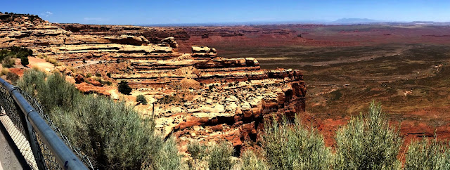
Last night I looked this road up, and learned its name, that the bluff face is 1100 feet high, that the road climbs that distance in slightly less than 3 miles.  That it was built in the 50s for huge uranium hauling trucks to carry cargo down to the town of Mexican Hat, where there was an enrichment facility or refinery.

But all I knew then was that I had entered some twilight zone, where the slightest wrong move would send me tumbling down to my death.  Not too different from the road from Ourey to Silverton, that I haven't told you about yet, except not quite as scary as that one.  Maybe because there was a little mound of dirt at the edge of the road that kept me from seeing the very edge of the dropoff, maybe because I had already had the experience once, maybe because I wasn't always on the outside, as the twists and turns put me on the inside as often as the outside.

The stated speed limit was 15, there were lots of times when I was going 5 mph.  As I climbed, I could see vehicles before me, and perhaps 5 or 6 passed me going down on my traverse of the Dugway, which probably lasted no longer than 15 or 20 minutes, but which seemed like much longer. There were pull over places, most of which had a car or two, and people standing around looking out over the Valley of the Gods in the desert below.  But I wasn't going to stop for anything.

Except at one point I rounded a tight curve and found the road ahead really narrow, and a van was heading down.  I stopped then, and backed up around the curve to where the road was wider, so the guy could come down and get around me.  I think that spot was probably the narrowest, and of course then I was on the outside, and I gave great thanks that no one else was coming down as I crossed that part.

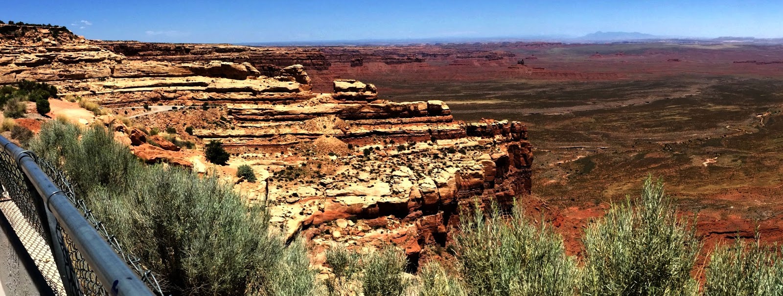
Finally I got to a much wider place, with a big turnout, and a waist high hurricane fence around the edge.  I stopped then, and got out, and looked around.  The desert stretched out below, filled to the east with the many tall monuments of the VotG, which seemed now like little statues or sand castles. Toward the west the bluff face, which turned out to be the edge of a mesa, I learned later, stretched out in a huge concave curve for miles and miles.  I took a picture, but like so many pictures I have taken, show nothing of the grandeur or scope or depth of the scene.

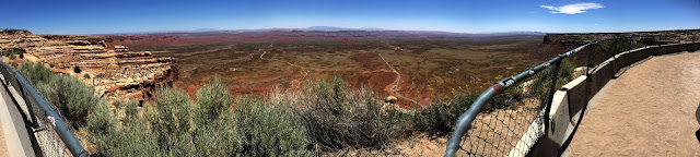
Sweeping panorama from the top of the Dugway
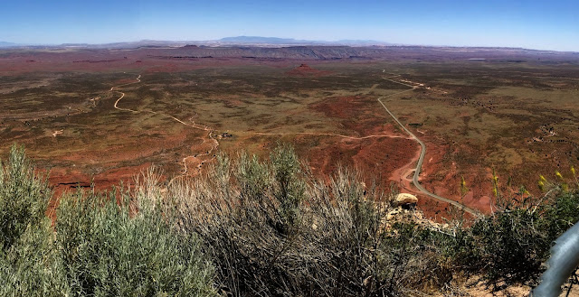
Detail from the center of the pano.  The blacktop road I came in on is visible; the smaller dirt road to the left traverses the Valley of the Gods.
Detail from the left of the pano.  The structures making up the Valley of the Gods are visible behind the lighter outcropping of the mesa edge we just came up across, and continue on into the vanishing background.
In my looking around on the internet last night, I found lots of youtube videos about this stretch of road, and many photos.  Excerpts from a few reality type travel channel shows as well.  Statements about how the ride south (down) was better, because you could see everything out in front of you (I had already decided I was glad I had been going up, for a similar reason). Comments from people seem split between people who loved it and people who it scared.  Color me in both camps.

At the pullout there was a van with a guy and a girl and we mutually exclaimed.  They were locals, showing visitors from AZ the sights.  The visitors never got out of the van, while I was there.  He told me about the uranium mining trucks, and that now I was at the top. That really relieved me, as I had thought that I faced a similar ride down, not knowing that I was on a mesa, and not just climbing over some two-sided feature.

The rest of the short ride on that highway was a pleasure, as my fingers' death grip on the wheel gradually relaxed.  I was on the way the one of the most beautiful parts of my drive, and I didn't even know it yet.


Sunday, June 19, 2016

Drive from Cripple Creek to Highway 50 made on Saturday, June 18

I write early Sunday morning from a motel in Durango, CO.  A father's day present to myself, I thought I deserved a motel stay.  Plus, all the campsites I stopped at were full.  Still made my own coffee (better than any motel's coffee) over the little camp stove, though.

Yesterday was the most incredible drive.  Moments of breathtaking beauty, moments of knee-shaking fear.  Quite a few hours on the road for a paltry 200+ miles, but what miles!

The drive from Cripple Creek to highway 50 way down in southern CO was mysterious at first, as one map program showed that there was a way to go kinda sorta directly, but another only showed a prohibitively circuitous route.  And Mike's atlas, 2006, which is proving to be such a help to me, showed no way at all.

Anyway, there was a drive, and it was lovely.  Cripple Creek is a bit like Eureka West, lots of elevation change, lots of old restored buildings, lots of tourist draw (old West mining motif).  Right through town for me, then up and up (though we started at better than 9000'), then out into a succession of lovely wide valleys, some with lakes, some just beautiful wildflower bedecked pastures.  Surrounded by what seem to be gentle hills, not craggy mountains, though these hills are at uber elevations. Made me think of how neat it must have been to find these lovely areas after the incredibly difficult climb from the eastern Co plains for the early pioneers and settlers.  Cropland was pretty much left behind in KS, and landuse here seems to be pasture for very few cattle, and otherwise just open. Anyway, I was in mild dropjawed wonder mode, as new vistas continually opened as I moved into different areas, and from time to time there were the glimpses of snowtopped big craggy mountains in the distance.

Big long descent, then, toward the scenic highway 50 Mike's atlas had suggested.  During that leg of the trip, the little Camry was tabulating 55 MPG!  Well, if I had been impressed with the scenery of that leg, the piece of road up next took impression to the next level.

Basically, there was a long stretch of road that ran along the Arkansas (I think) river, a strongly flowing, rapids-filled river maybe 50-75 yards wide.  And because the river's course was tortuous, so was the road.  And because the river was in a canyon it had carved, so was the road.  And what a canyon: narrow in places, wider in places, with walls of huge rock formations, around which and through which the road twisted and turned.  Rocks as big as houses, airplane hangers, multi-storied office buildings.  Craggy slopes that began at the edge of the road and shot up at a 45 degree angle for hundreds of feet.  Areas where the road was enclosed by rock walls, areas where the view opened out, presenting vistas of mountains farther off. And all the while, the river running rapidly next to the road, at times open, at times rock strewn and rapids filled.

Not much chance for pictures, sorry to say.  This type of drive is a challenge, as there is so much desire to look around, but one going at speeds ranging from 40 to 65 mph, one of a long train of cars. Road is two laned blacktop, not many places to pass, which was fine as I drove as slowly (for a change) as I could get away with, and kept as large a gap between the Camry and the car in front as I could, often a hundred yards or so.

I took a video at a roadside stop, but it is large in size, and I don't know if it will upload or not, from where I am.

And this part of the drive was only the beginning of the day's experiences. However, now I need to get on the road, heading for Bryce Canyon for this day's endpoint.  More later, if the internet gods so decree.


Saturday, June 18, 2016

No Reservation on a Weekend? Too Bad! Friday, 6/17

Things didn't go as planned today.  I originally planned to head towards Estes Park, Co, to check out the  Rocky Mountain National Park.  But that was a little longer run than I had hoped for, and also I had read something about gradually acclimating to altitude.  So I routed through Colorado Springs, instead, intending to go west a while to a Mueller State Park.  When I got to CS, I called Mueller, and they were FULL (and this at noon).  So I saw on the map that there were a number of private campgrounds, so I just went ahead up highway 24 west.

But, each one that I stopped at was full, as were the motels I tried.  When I got to the town of Divide, a lady advised me to head south to Cripple Creek, where I would find lots of campgrounds and motels.  Opposite direction than I wanted to go, but...

The 20+ mile drive was like the Pig Trail, but with ups and downs two or three times the PT's.  Incredible views, as there had been on the highway 24 earlier, but when everybody is whizzing by at 65, there's not a lot of time to rubberneck. But on this little road, I could look around a little, and enjoyed the drive a lot.

Found a KOA campground and got settled.  Nice spot, no one else in sight.  I unpacked and saw my first Aspen trees up close, even took a picture.


Rick's first Aspen trees

Campsite 3, tent behind me
 Felt a little blue last night, as things weren't going as planned.  But in the atlas my neighbor Mike had loaned me, he had marked the best routes in blue.  And the southern route through Colorado, which I hadn't planned to take, had a large stretch that began just an hour and a half from where I was.   So I dropped my boot to the ground and kicked my plans around in a sharp turn.  In the morning I would head south instead of north.

Night became cool, 50 when I awoke.  I won't say I am getting used to spectacular views, but there was another one just fifty feet from my campsite.  I got an early start, and was on the road by 9.

View out the tent as I shiveringly pulled on sweats
For the last three hours I have been driving along the most incredible road I have ever driven.  But you're going to have to wait till tomorrow to hear about that, as I am only about halfway to today's goal, and I want to put on some more miles.  I type from Gunnison, Co, and hope to reach the million dollar highway today.

Friday, June 17, 2016

Campsite 2, Lake Scott State Park, 6/16

A bit of a let down after the first place, though it looked to be superior during internet research.  The park is surrounded by an encircling container of bluffy hills.  The lake is long and slender, serpentine, created by a dam. no real open water, more like a very small twisty cove on Beaver Lake.

The park surrounds the lake, and consists of a number of campgrounds at various sites, several with vacant spaces, and several with lots of people.  I learn that there is no swimming except at the public "beach" which is tiny and crowded, not my thing.  As I entered the park I saw a small campground near the entrance with shady trees, but didn't consider it as the lake was like a canal at that point and would not have had good swimming.  But since swimming was out, I paid my fee ($19 this time) and returned to that site.

Lake Scott at my campsite early am
Shortly after I arrived and was setting up, two other families arrived, but with enough distance between sites that there was no feeling of being crowded or that one's privacy was encroached upon.  No one spoke, though one waved.  I felt funny with just those few folks around, so went and introduced myself to each briefly.  Then I was comfortable to go about my own business.

Campsite at Lake Scott State Park
Tonight I cooked: venison sausage (Thanks, Tracy) with red bell pepper and onions, on the cool little alcohol stove I got on ebay.  More about that later if I find myself short on things to say one day.

I discover the anti-joy of biting black flies here, quite a few of them.  They don't seem to be at all put off by Off!.  But there is a strong breeze when I arrive, and that keeps them mostly off until it dies around sundown.  Tonight I tried the small battery powered fan, and it works wonderfully.

Campsite one, Eisenhower State Park, 6/15, continued

Sorry, this one is a little out of order.  Back to the first night's camping.

The big thunderstorm came in after I had been asleep several hours.  I stayed awake as long as I could, 11pm, watching as it got closer and closer.  Diffuse bolts lighting up 1/4 of the western sky, and occasionally sky/ground or cloud/cloud bolts, huge and jagged and bright.

I put up the fly and crawled into bed.  Wind had picked up considerably, so no difficulty with heat; temp was dropping as the front came closer.  The rain started and brought me only slightly up from deep sleep, the pleasant feeling of being inside and dry while it is raining outside.  In time the intensity of the storm increased, and I became fully awake.  Though the tent was under the tree, on the lee side of the tree, the wind was fierce, shaking the fly and tent continuously, and bending the tent halfway to the ground during the most intense gusts.  I kept waiting for the whole tent to collapse or blow away, but it sprang back erect between gusts like a real champ.  (Thanks, Mike, Tracy)

In the morning, grass was already dry when I crawled outside.  The upwind tent peg, triangular in cross section to resist bending, was quite deformed by the wind's pressure on the tent.  But no sprung panels, no opened seams.  Yay, little tent!

Along the way, day 2, Thursday 6/16

I began to get a feel for the plains today, as fields got larger and one could perceive monumental expanses of open countryside.  it wasn't hard to imagine grassland as far as the eye could see, no buildings, no fences, no trees.  The circle of the earth takes on real meaning here.

As i moved westward, corn gave way to more wheat (they grow a lot of wheat in Kansas) and some low growing bring green row crop--sorghum?  Though I was on traveled two lane blacktops, towns were few and far between.  There is still a lot of between town space in Kansas.

At one point I could see buildings on the horizon, so left my route and discovered various businesses, including a McDonald's on some strip of some town which remains unidentified. though I'm way too healthy to eat McD's (ha!), i felt I had to at least order something with my coffee to justify an hour of wifi.  My guilty pleasure, a triple cheeseburger with jalapenos.

The counter lady, an East Indian, said "What?"  I repeated--she asked the manager, and of course it turned out they had not a jalapeno in the building.  The lady suggested that I must be from Texas.  I told her all the McD's I knew in Arkansas (admittedly a small sample) had plenty of jalapenos.

What Kansas lacks in jalapenos, it makes up for with... roundabouts.  These are traffic regulating road systems used in place of crossing intersections.  They are common in Great Britain, I think, and I have seen more than a few around New England.  But Kansas, who would have thought?

Terrain: flat to gently rolling hills all day,  But as I approached my destination, Lake Scott State Park, I began to see hills, and bluff lines of stone.  I know I'm a long way from the foothills of the Rockies yet, so I suppose they're just a localized topological characteristic.


Thursday, June 16, 2016

Campsite One


I am invited to drive around the park and choose a camping area.  There are a number of organized primative sites with drive in parking spaces, and the park is practically empty.  But one area, Sailboat Beach, has a sprawling grassy area running down a gentle grade to the water, with the option to put up a tent anywhere.  With the temperature hoving at 100 degrees in bright sun at 4pm, I select a spot fifty feet from the water, under the shade of a spreading leafy tree.

Returning to pay the $16 I owe for a night's camping, the office has closed, and I go to the small store instead.  The older gentleman behind the counter informs me that he grew up in Clinton, AR, and we exchange stories of our use of the internet to solve problems involving repairs of things.

Back at the site, I am the only human in sight, though a bunny greets me as I drive down to the shady tree I have selected.  The heat is like a heavy blanket after hours in the AC of the car.  I open a Negra Modelo, and begin to unpack the car.  Tent up on the lovely thick grass, mattress inflated, food and gear ready on the picnic table.  The water beckons, and I can no longer resist.  As no one is around I consider a skinny dip, but instead timidly don trunks.


The bank has a very gradual descent, reminding me of the Gulf of Mexico on the east coast of FL.  I am 40 feet off shore and the water is only waist deep, a far cry from Beaver, where I am over my head five feet from the shore by the cabin's dock. The thermocline here is much shallower than at Beaver--the surface water is bathtub warm, but only 2-3 feet below the surface, the cold layer almost takes my breath.  But I feel as though I have been waiting for this water all day, and I swim my required number of strokes and then float around quite a while.

I've been noshing all day on road food--sausage, cheese and crackers as a nod to trips of yesteryear, and on carrots and jicama (Karim, I'm finally eating the jicama!)  So I am full after the three beers and decide not to cook anything,  I packed lots of fresh healthy food from home--HB eggs, sauerkraut, summer sq and zuccini, yogurt.  So I'll be eating that stuff for the first few days, before i start in on the canned goods, brown rice, vacuum packed soups, etc.

Checked the weather as the western horizon was getting dark.  50% chance of Tstorms 8-11 tonight.  Piled all the gear on the picnic table so I can tarp it if it rains.  Tent fly off to get the breeze, but ready to put it up if the rain arrives.

Before the storm?
It is earlier than sundown, but the sun has  been behind dark clouds as I've been writing this.  Breeze has pickup up--now maybe 7-8mph, very peasant, in from the lake and thus not as hot as earlier.

Reflections on the way

I loved the smaller roads, and routed through Pea Ridge town itself (nice HS football field/stadium), up the MO side of the KS/MO border a while, then N into KS and finally to Malvern Lake and Eisenhower State Park.

On the way, corn, lots of corn, even in MO before crossing into KS.  big fields of the most verdant green you could imagine. Very lovely.  And they are recently haying, large bales dotting new mown fields.  Into KS, I began to see the occasional new mown fields with the most rich golden tan stubble.  These are wheat fields, newly mown.  The contrast betweeen the bright green corn fields and the warm golden stubble fields was a visual treat.


Passed through a number of small towns, but not as many as I expected--there is a lot of open space in KS.  Fort Scott and Burlington are a couple of town names that I remember.  In one town, there was an artificially constructed grassy knob, 25-30' high.  And on top an equally tall sculpture of a pair of praying hands.  Next to the sculpture was one of those huge auto dealership American Flags, flying at half mast, no doubt for the Orlando horror.

Another thing that impressed me was a windmill farm.  These mills, 25 or 30 of them, strething to the horizon in a long line, were enormous three bladed affairs.  I have seen the type before, off the I40 on the way to Tulsa, but I guess they were farther away, as I had never felt the sheer magnitude of the structures as I did these.  They were turning slowly, maybe 10 rpm, each with the blades in different positions.  Stark white against green vegetative foreground, and the blue and white background of the cloud strewn sky.  Beautiful, and elegantly producing pollutant-free power.

On the road…

Finally! And Bill, that's probably as much Jack Kerouac as you are going to get today.

Got off a lot later than planned quotation marks 10:50", but I'm on the schedule, so that is fine.

Planned the route this morning on the home computer to Eisenhower State Park using smallest roads I could find, that were still going in the general direction. For some reason I could only transfer the route to the iPad and not the iPhone, for turn by turn directions.

T-Mobile gives you 200 MB of cellular data free each month which is nice of them; I signed up for that plan on my iPad. But halfway to the park the directions stopped; it turns out you have to have cellular data available to use the Google maps route, and t-Mobile coverage dropped out right there. (I didn't expect this – it bodes ill for the navigation further west where cellular signal is limited).

I switched over to the iPhone (Verizon) at that point, as there was good Verizon signal, and I arrived at Eisenhower State Park with no further delay. Mileage: 258 miles; time: approximately five hours; average MPG for this leg: 41.7!! 😀

Posting note: I am posting this Thursday noonish at a McDonalds.  Posting through email isn't working as well as I would like.  So a day's posts will probably come through a day later.

Tuesday, June 14, 2016

There's a lot to DO..

Getting ready for a trip that might last a month!

The last couple of days have been hectic, but with mere hours to go before take off, I am feeling as though things have pretty well fallen into place.

Clothes packing for trips is a new task for me.  I planned shorts and tee shirts, until friends told me I might well run into pretty chilly temperatures in the Rockies.  And Kay and Del told me earlier this evening that it is 57 there tonight.  So now there is some variety in my ensemble!

The picture of extremely poor quality is everything that I should need for a month, with the exception of cold food, and water, which go into the back seat with the hanging up clothes.  I thought it would be cool to make a stop action movie of packing everything into the trunk, and so I did.  Or I thought I did.  But you are just going to have to imagine it this time, as it didn't work because I didn't know what I was doing.  But it all fit into the trunk with room to spare, even the box of Cabernet that didn't get into the picture.


I will figure time lapse out and use it another time on the trip, though.

I want to add a thank you here to Robert, who is going to watch out for the house and the cabin while I am gone.  He promises to keep the barbeque grill and the dock in working condition until I return.

Sunday, June 12, 2016

This is the one I'll be using

I was experimenting with two different blog sites to see which I liked better.  The other one, Blog.com, started off looking good, but I have been unable to access it for a day and a half now.  I did a little research, and though of course it could be user error :), I don't think it is.

So, Google's blogger platform, where you are reading this now, is the vehicle we will use to explore this little road trip exposition.


Thursday, June 9, 2016

Six days until take off.

Although I have been casually preparing for the trip for several weeks, things become more serious now.  Today is Thursday June 9, and I hit the road next Wednesday. This gives me only five days after today to get everything lined out.  Last evening and this morning I detailed the interior of the Camry, something I have liked to do before a trip.  Later I will wash the car as well.

I think I have all the camping needs accounted for.  I am taking some staple food items, but will be shopping daily along the way, I hope.